
Season Dates: All Year
Fees: None
Coordinates:
- Main Camping Area – N 43 21 38, W 120 22 26
- Juniper Camping Area – N 43 21 20, W 120 23 14
- Alternate Camping Area – N 43 20 98, W 120 24 11
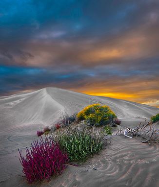
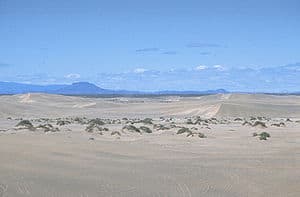
Piled up over 60 feet high in spots, the Christmas Valley, Oregon Sand Dunes are an 8,000-acre ATV play land that attracts visitors from all over the United States. Due to prevailing winds out of the southwest, sand has been transitioning through the area for well over 10,000 years.
This area is BLM land and mainly consists of medium sized dunes with some fun sand bowls. The main access roads are largely not maintained and these roads can also be very muddy in the spring so 4WD is recommended.
As you travel around the area of the sand dunes, be sure to stay on routes marked “open road.” Fossil Lake, a delicate paleontological site, is protected by several federal laws and it is closed to all vehicles. Constant wind action has blown most of the fine sediments out of the pleistocene-age lake bed to create the Christmas Valley Sand Dunes. Fossil Lake (a 6500 acre dry lake) is off-limits to OHV use and has prehistoric post-ice age fossils such as camels and mammoths. Please note there is private land surrounding the dunes and the Lost Forest. Respect land owners by not cutting any trees for firewood, carry out what you bring in and respect your fellow users. The right to use private property is a privilege and will remain open as long as people respect it.
Christmas Valley contains 11,000 acres of sand dunes available to off-highway vehicle use. The area “open” to vehicles is surrounded by several sensitive areas with more restrictive vehicle designations. The Fossil Lake area is closed to vehicles (and is fenced off), and in the Lost Forest vehicles are restricted to roads which are posted open. Although the bare dunes are open to vehicles, since they are within a Wilderness Study Area, vehicles are required to stay on trails that are posted open until they reach the bare dunes.
The area is bordered by and includes private land. Please respect their property, or you will find yourself fenced out.
Wilderness Study Area – In 1981, 16,440 acres were designated as the Sand Dunes WSA. Although BLM later determined in 1991 that the area was not suitable for Wilderness, the area must be protected until Congress makes the final decision.
The dunes are composed largely of ash and pumice which blew into the area over 7,000 years ago when Mt. Mazama erupted forming Crater Lake. During dry times of the year, it can get quite dusty.
Directions:
Follow State Highway 31 south from Bend about 60 miles and turn east on County Road 5-10 toward Fort Rock/Christmas Valley. After about 20 miles turn right (east) on 5-14 (Christmas Valley Hwy) to the community of Christmas Valley. Continue east past Christmas Valley approximately 10 miles, then turn left (north) on 5-14D (Fossil lake Rd.) and go 8 miles to a “T”. Turn right on 5-14E (gravel), and follow it until you see small signs for the Sand Dunes (approx. 6.85 miles to camp). Road narrows and becomes washboarded. It is about 16 miles from the dunes to the town of Christmas Valley.
Elevation: 4290 ft.
Camping:
Juniper Camp – Stay on main road until you see signs for Juniper Camp.
½ mile west of the Lost Forest.
Rules:
- Whip flag that extends 8 ft. from the ground
- Stay on designated routes. Any trail without an “Open road” sign is closed.
- No person shall operate an off-highway vehicle in a manner likely to cause environmental damage. Do not run over vegetation.
- Do not collect firewood from the Lost Forest.
- Bring in, dispose of or possess any firewood containing nails, screws, or other metal hardware.
- Spark arresters are required on all OHV’s.
- Fossil Lake ACEC is closed to vehicles.
- Lost Forest RNA – stay on designated trails only.
- Respect private property in the area.
- No trash collection. Pack it in. Pack it out.