
Season Dates: All Year
Fees: None
Coordinates: 43°22′19.5″N 121°04′26.4″W
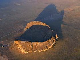
Fort Rock is a volcanic landmark called a tuff ring, located on an ice age lake bed in north Lake County, Oregon, United States. The ring is about 4,460 feet in diameter and stands about 200 feet high above the surrounding plain
Recently, the age of Fort Rock has been estimated at 50,000 to 100,000 years. This coincides with a period of time when large pluvial lakes filled the valleys of central Oregon and much of the Great Basin of the western United States. At its maximum, the water in Fort Rock Lake was estimated to cover nearly 900 square miles and was about 150 feet deep where the Fort Rock tuff ring formed.
Fort Rock was created when basalt magma rose to the surface and encountered the wet muds of a lake bottom. Powered by a jet of steam, molten basalt was blown into the air, creating a fountain of hot lava particles and frothy ash. The pieces and blobs of hot lava and ash rained down around the vent and formed a saucer-shaped ring of lapilli tuff and volcanic ash sitting like an island in the lake waters. Steam explosions also loosened angular chunks of black and red lava rock comprising the valley floor. These blocky inclusions are incorporated into the fine-grained tuff layers at Fort Rock. Waves from the lake waters eroded the outside of the ring, cutting the steep cliffs into terraces 66 feet above the floor of Fort Rock Valley.